After finishing my map of the most common road suffixes by length, I realized I could also map each individual road, colored by its suffix. This has led to the loveliest maps I’ve made.
Driving around your city, you’re probably somewhat aware of Avenues and Boulevards and Streets and Roads and so on. Here in Portland, at least, I know that Avenues run north-south and Streets run east-west. However, it’s hard to get an overall view of how all these road designations knit together. By coloring them, we can suddenly see a new, stunning view of what we normally take for granted.
My code for this project is on Github if you’d like to make your own maps instead.
Prints
There’s been some demand for prints–they’re available now on Society6!
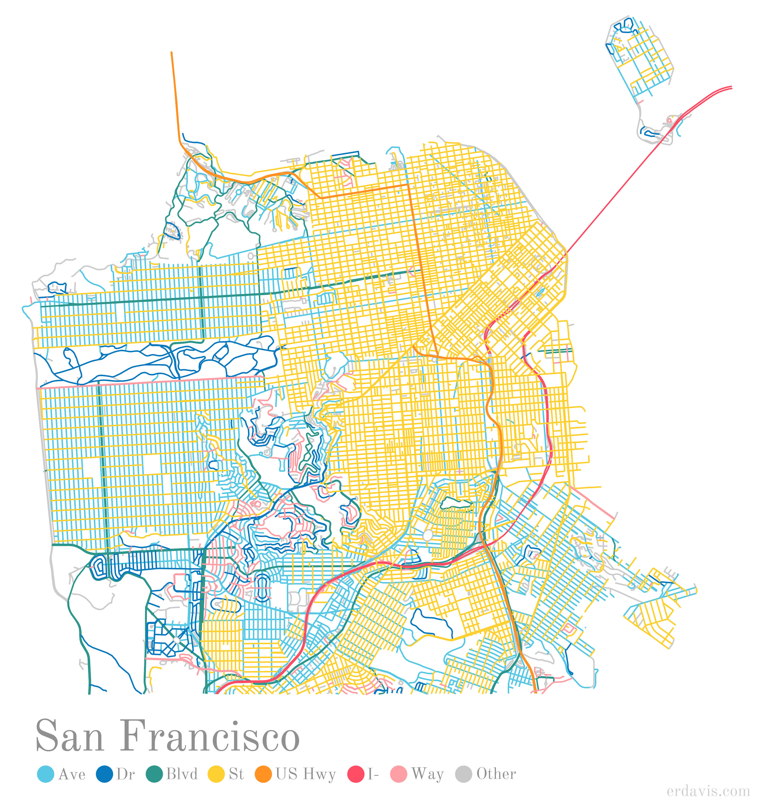
San Francisco
For example, here’s San Francisco. I particularly love this for the divide down the middle of the city–streets on one side, avenues on the other.
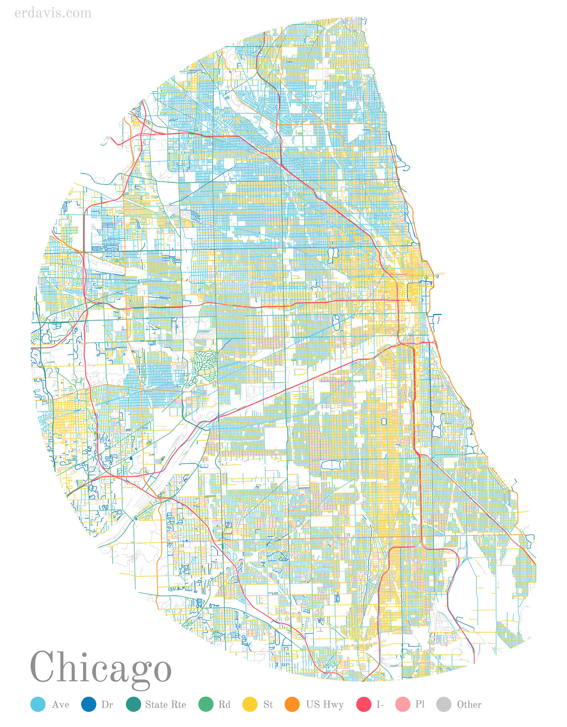
Chicago
Chicago has a ton of unnamed alleys (shown as “other” on the map)… so many, in fact, I made them much narrower than the other streets so they wouldn’t blur into one big blob.
Houston

Los Angeles
Los Angeles is so huge it’s difficult to show all of it. I’m particularly fond of this view of downtown. The interstates remind me of veins, pumping traffic through the city.

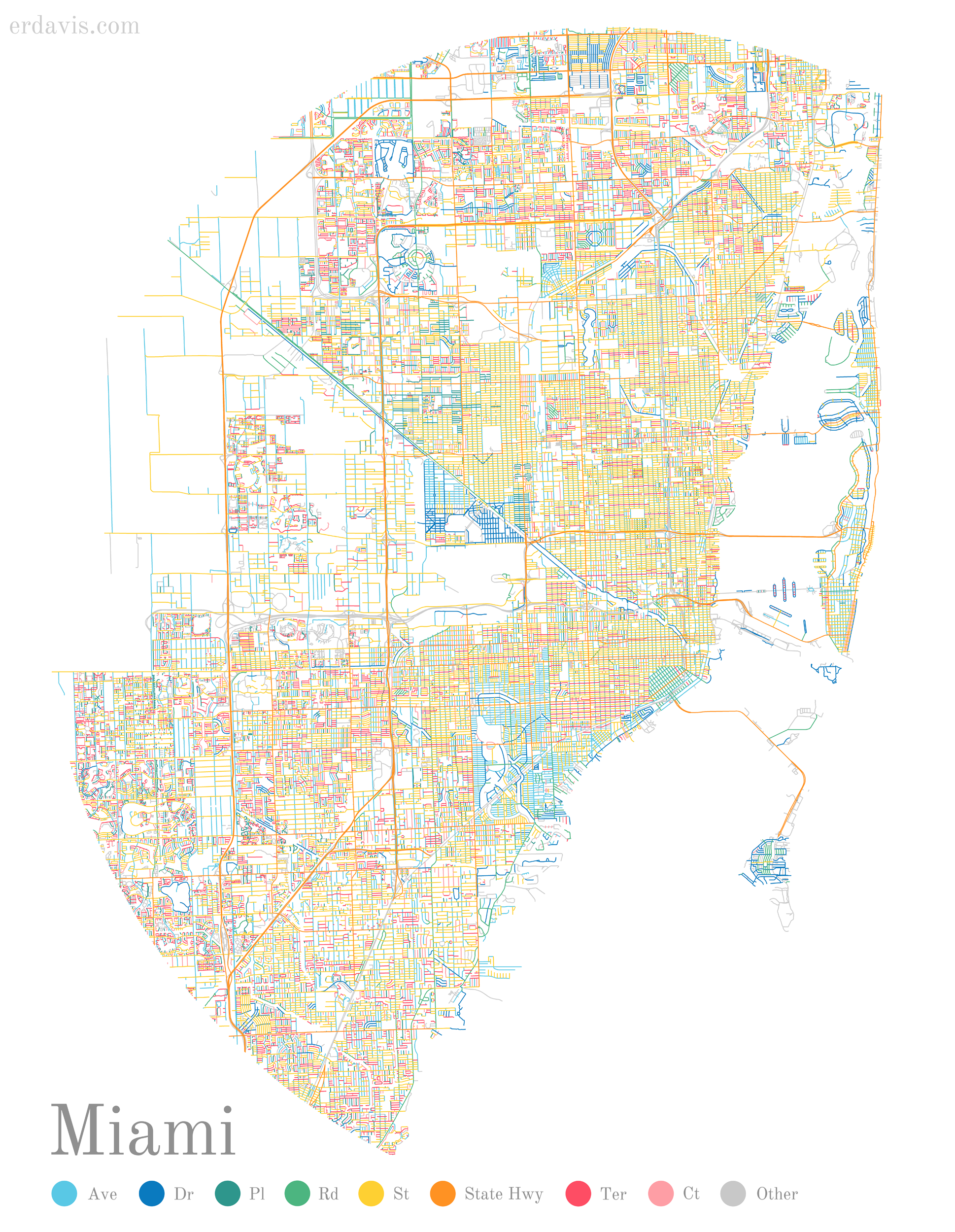
Miami
Completely unintentionally on my part, Miami came out dominated by hot shades of yellow and red.
New York City
NYC, like LA, is too large to nicely fit in the format I’m presenting. Instead, here’s most of it, plus some New Jersey on the side.

Seattle


Really nice maps, fair play to you, they look very well!
LikeLike
The maps look really cool. I imagine printing and hanging them on a wall would make an interesting decoration.
LikeLike
[…] erdavis.com […]
LikeLike
Is there a way we can get prints of these?
LikeLike
I might try to get some up after I do another batch of cities, but you’re also welcome to get any of them printed for personal use!
LikeLike
I would be interested in Erie, PA. A nice orderly network of numbered East/West versus named North/South streets.
LikeLike
Really neat visualization. I tried to apply it to a bilingual context in the Ottawa region in Canada (border with Quebec province) and it gives some interesting results. What do you use to create your legend?
LikeLike
Thank you–‘d love to see what you made! I just did the legend manually in Photoshop.
LikeLike
I figured. I did mine using QGIS. You can see my first try here: https://twitter.com/Emmanue17939044/status/1174723395629604865?s=20
I will try now your worldwide script using OSM. This is brilliant.
LikeLike
This such a cool visualization of the city!!! I’m obsessed. Do you mind if I run with this idea for some other cities I’m fond of? I have a feeling these would make for gorgeous wall prints and now I want to make a series for myself! Hahaha
LikeLike
Absolutely! I’d love to see what you make, too
LikeLike
Boston boston boston!!
LikeLike
Boston boston boston please!!
LikeLike
[…] [Image: erdavis.com] […]
LikeLike
Yes: Boston, please!!
LikeLike
Good stuff.
Any thought of doing a time series for a city to see if certain types become more or less prevalent over time?
LikeLike
How can I get a high quality enough image to print it for personal use? thanks in advance.
LikeLike
The images uploaded to the blog are pretty high-res–if you click on one, doe that resolution work for you?
LikeLike
[…] By Erin Davis […]
LikeLike
[…] used Erin Davis’ code to make pretty maps of parts of the DC […]
LikeLike
[…] Visualisations of various cities by the street name suffix, eg, Street vs Road vs Avenue […]
LikeLike
[…] done many more, too, which you can find on her site here, and more recently including more global cities, […]
LikeLike
[…] See her work here. […]
LikeLike
[…] The Beautiful Hidden Logic of Cities – fantastic map visuals […]
LikeLike
This is very cool!
Question: is title/legend also part of your code? I haven’t had luck finding the bit where you add that. Both placement and fonts.
I’m trying to create a wall map of my hometown in Ukraine – working with non-Latin alphabet is all sorts of fun, haha.
LikeLike
Thanks! I did the legend manually in photoshop. The font is Old Standard TT. I’d love to see what you come up with!
LikeLike
Thanks! I figured as much!
I’m not here too much for the color coding of streets, but for the underlying aesthetic of the map: loving the radial idea!
Here are a few versions I got so far, but I’m still iterating: https://twitter.com/taraskaduk/status/1204770310261747716
LikeLike
Here is the final version: https://taraskaduk.com/2019/12/20/print-maps/
LikeLike
It looks awesome! As to the reason why you need two CRSs, this is how I understand it: 4326 is the code for standard lat/long projection. The data comes in this format, but it doesn’t come already tagged that it -is- in that format. So you first need to declare that it’s in lat/long format (crs 4326), and once that’s done, you can re-project it into whatever projection works best for your purposes (in this case equal area conic for Europe, 102013)
LikeLike
[…] E R Davis | ‘The Beautiful Hidden Logic of Cities’ […]
LikeLike